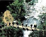
 Part of
the 23,000 kilometers (approximately 14,000
miles) of roads built by the Incas in South
America, this is Peru's most famous trekking
route and possibly one of the most spectacular
in the Americas. Every year; some 25,000 hikers
from around the world walk along the
extraordinary 43 kilometers of this stone-paved
road built by the Incas leading to the
unassailable citadel of
Machu
Picchu located in the depth of the
Cusco
jungle. The journey starts in the village of Qorihuayrachina, at kilometer 88 of the
Cusco
- Quillabamba railway and takes three or four
days of strenuous walking. The route includes an
impressive variety of altitudes, climates and
ecosystems that range from the high Andean plain
to the cloud forest. Travelers will cross two
high altitude passes (the highest being
Warmiwaсuska at 4,200 m.a.s.l.) to culminate the
hike with a magical entrance to Machu Picchu
through the Inti Punko or Gateway of the
Sun.
Part of
the 23,000 kilometers (approximately 14,000
miles) of roads built by the Incas in South
America, this is Peru's most famous trekking
route and possibly one of the most spectacular
in the Americas. Every year; some 25,000 hikers
from around the world walk along the
extraordinary 43 kilometers of this stone-paved
road built by the Incas leading to the
unassailable citadel of
Machu
Picchu located in the depth of the
Cusco
jungle. The journey starts in the village of Qorihuayrachina, at kilometer 88 of the
Cusco
- Quillabamba railway and takes three or four
days of strenuous walking. The route includes an
impressive variety of altitudes, climates and
ecosystems that range from the high Andean plain
to the cloud forest. Travelers will cross two
high altitude passes (the highest being
Warmiwaсuska at 4,200 m.a.s.l.) to culminate the
hike with a magical entrance to Machu Picchu
through the Inti Punko or Gateway of the
Sun.
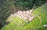
One of
the main attractions along the route is the web
of ancient settlements built in granite rock by
the Incas like Wiсay Wayna and Phuyupatamarca
immersed in an overpowering natural scenery.
Hundreds of species of orchids, multicolored
birds and dreamlike landscapes provide the ideal
backstage for a route that every hiker should
walk at least once.
Description of the Inca
Trail to Machu Picchu route
Based
on a 4 days / 3 nights tour.
The total
distance of the trail is approximately 39.6 Km.
and begins at Km. 88 at a place called
Q'oriwayrachina. To begin the trail, you must
cross the Kusichaca bridge, (an important Inca
bridge which using Inca techniques, has been
built with steel cables which allow visitors to
cross the Urubamba River). Then you head over to
the left bank through a Eucalyptus grove and
start the day calmly.
Almost
immediately, you will come across the
archaeological complexes of Q'ente, Pulpituyoc,
Kusichaca and Patallaca. From this last spot,
follow the trail along the left side of the
Kusichaca River in the area with the same name
where you will not only see the bridge but also
you will find tombs, aqueducts, terraces. roads
and a canyon. Continue until you reach the small
peasant village of Wayllabamba and Inca
aqueducts. It takes around four hours to cover
the 9 Km up to this spot. One can camp here for
the first night, but for comfort we recommend
staying in Llullucha 1.6 Km further
on.
The
second day is more difficult as the hiker will
have to climb up to 4,200 meters, crossing the
Warmiwaсusqa pass, the first and the highest. If
you suffer from "soroche"
(altitude sickness) it is best not to stop and
descend quickly to the valley of the Pakaymayu
River, where you can camp. This spot is 7 Km
away and an approximate eight-hour
walk.
Inca trail
The third
day is the longest but most interesting. You
will be able to visit impressive archaeological
complexes such as Runkuraqay, the second pass,
at 3,800 meters above sea level. This is a
walled complex with interior niches that perhaps
was a small place for rest, guard post and
worship place. After crossing the second pass,
descend to Yanacocha (the black lagoon), to then
climb up a path with stone steps until you reach
another cluster of buildings which attracts the
attention of visitors. This spot is called
Sayaqmarka a pre Hispanic complex with narrow
streets, buildings erected on different levels;
shrines, patios, canals and a protecting outer
wall. At the top of the buttress one can see
many constructions which lead one to suppose
they once were a temple and an astronomic
observatory which had a permanent supply of
water and excellent food
storehouses.
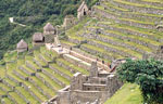
Sayaqmarka is a place filled with
mystery and enchantment. The approximate
distance to Runkuraqay is 5 Km, which takes 2
hours. This complex lies at 3,600 meters above
sea level. There are excellent paths and a
tunnel through this complex. We recommend you
camp near the Phuyupatamarca ruins or 3 Km
further on at the Wiсay Wayna Visitors Center,
where one can buy food and drinks or use the
bathrooms. The Phuyupatamarca ruins are better
preserved than those seen before
now.
It has a
solid base built down to several meters in some
cases. The Wiсay Wayna ruins were given the name
possibly because of the abundance of a beautiful
type of orchid which flowers nearly year-round
in the whole area. The Peruvian government and
the Viking Fund signed an agreement in 1940 to
investigate the area, and sent the Wenner Gren
expedition led by Professor Paul Fejos. But
despite the expedition, there is no precise
information about the specific function of six
groups of dwellings near Machu Picchu. They are
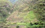
divided up into four well-defined sectors which
are: the agricultural sector with many terraces,
the religious sector, the fountain sector and
the residential sector where the houses are
located.
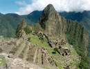
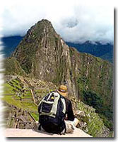
On the
fourth day, which starts around 8 A.M., the
walker arrives at Machu Picchu at around 11 A.M.
after 8 Km of hiking through the jungle. Follow
the signaled route and drink some water at the
Wiсay Wayna Visitors Center. The path is clearly
marked but try to avoid getting too close to the
cliff edge.
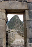
It is
forbidden to camp in Inti Punko. Leave your
equipment at the control gate and enjoy getting
to know the most important monument in this part
of ; the continent. You have time to walk around
Machu Picchu until mid-after-noon. Check train
timetables to return to Cusco.
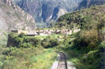
If you
plan to stay in the town of Machu Picchu (Last
called "Aguas Calientes"), the distance from the
station of Puente Ruinas to Machu Picchu is 2
Km. It takes around 20 minutes to walk down a
narrow path which runs parallel to the train
line.
We
recommend you check for trains before walking
the path.
Courtesy: PromPeru
Inca
trail Peru
Climate and Environment
The
climate is relatively mild all year- round, with
heavy rains from November to March, and dry and
hot weather from April to October, which is a
recommendable time to visit. The annual minimal
temperature runs from 8° to 11.2°C. In the
months of June, July and August the temperature
can often fall below zero. I
nca trail Peru
The annual maximum temperature
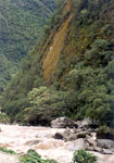
varies from 20.4° to 26.6°C. The terrain is
fairly jagged, with many gullies and streams fed
by glaciers which eventually pour into the
Urubamba river, which crosses the area forming a
deep valley which runs through the granite base
of Vilcabamba for more than 40 km through a
variety of eco-systems.
Landscape
The natural
surroundings are impressive and the balance
achieved between nature and Inca architecture is
striking.
The Vilcabamba mountain
range boasts peaks higher than 6,000 meters such
as Salcantay and Huamantay among others. The
blend of mountains, jungles and valleys create a
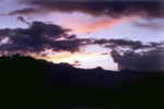
fantasy world where the spectacular dawn and
sunset are shrouded in mystery.
Fauna
This is abundant and
varied. The existence of species in danger of
extinction such as the spectacled bear
(Tremarctos omatus), the
Andean
Cock-of-the-Rocks (Rupicola
peruviana), the dwarf deer (Pudu
mephistopheles), etc. was one of the reasons
why the government decided to declare it a
Conservation Unit.
The park includes species
like the puma, Andean fox, river otter, Taruka
(Huemul deer), wildcat, ferret, etc. There are
birds like the Mountain Caracara, hummingbirds,
torrent duck, parrot, wild turkey, and many
other colorful smaller birds. There are also
reptiles like the Jergon Bothrops and the coral
micrurus snake (lethal for its venom), lizards,
frogs, and numerous Andean and jungle fauna
which inhabit the Sanctuary. This abundant
wildlife makes the Sanctuary ideal for tourists
and researchers who wish to watch or study the
animals.
Flora
The large natural
areas are filled with a variety of forest
species which vary according to the habitat. The
forest vegetation is represented by trees such
as cedar, romerillo or intimpa, laurel, etc.
There are also species like Ocotea, Pedocarpus, Guarea, Weinmania, Clusia, Cedropia, Cinchena,
Eritrina or Pisonay, and Ilex among others. The
decorative plants have made the Sanctuary
famous. Experts have identified more than 90
species of orchids, and many species of begonias
and puya cacti. Most of the area is covered by
herbaceous, shrub like and arboreal plants. The
varied conditions have created an ideal
environment for the growth of diverse plant life
that runs from thick jungle like the cloud
forest to the sparsely covered mountain
tops.
Archaeology
Apart from
everything that has been mentioned, there is
also the Incas cultural heritage. The Inca Trail
which was well built, crosses dense forests and
deep canyons. There are 18 archaeological
complexes dotted along the trail which can be
seen in all their splendor. These are made up of
housing, irrigation canals, agricultural
terracing, walls and shrines, which are
irrefutable proof of the existence of important
human
settlements.